First settled in 1630 as a part of Watertown, Newton
was incorporated as a separate community (Cambridge Village) in 1688. In
1691, it was renamed Newton, receiving its city Charter in 1873.
Located 8 miles west of Boston, Newton is a diverse community of 13
"villages", each of which retaining their own distinctive neighborhood
feeling and architecture. UPPER FALLS is one of the
six founding villages of Newton, and is believed to be the only village
retaining the name acquired prior to Newton's separation from Cambridge in
1688 (early high- way records of 1685 and 1687 refer to "Upper Falls").
Much of Upper Falls is now a local historic district containing more than
150 structures, many of which look much as they did in the early 19th
century. In those early days, the village occupied a wide territory,
including Newton Highlands (until 1865) and Waban (which became a separate
village in 1891). Although grants of land were made within its borders as
early as 1634, its first permanent settlers were John and Rebecca Woodward
in 1681.
 The first industrial venture in the
village (the first on the Charles River in Newton) was John Clark's
sawmill, erected on the east bank in 1688. This was soon followed, in 1710
and 1715, by a grist mill and a fulling mill (fulling is a process of
pounding and shrinking woolen cloth). Upper Falls' role as the leading
manufacturing village in Newton was quickly established.
The first industrial venture in the
village (the first on the Charles River in Newton) was John Clark's
sawmill, erected on the east bank in 1688. This was soon followed, in 1710
and 1715, by a grist mill and a fulling mill (fulling is a process of
pounding and shrinking woolen cloth). Upper Falls' role as the leading
manufacturing village in Newton was quickly established.
In 1782, Simon Elliot of Boston completed the purchase of the mill
site, and the older mills were joined by four snuff mills, an annealing
shop, a wire mill, a screw factory and a blacksmith shop. These buildings
remained here until 1823, when a company formed by Thomas Handasyd
Perkins (Elliot's son-in-law) replaced them with a large cotton mill,
under the name Elliot Manufacturing Company. Perkins was a noted
Boston merchantman - the principal benefactor in the building of the
Boston Museum of Fine Arts, the McLean Hospital, the Mass. General
Hospital, and the Perkins Institute for the Blind. The superintendent of
the new company, Otis Pettee, was among the first inventors and
manufacturers of cotton machinery in America. The first building on the
site was a foundry, built under Pettee's supervision. Not only was most of
their cotton machinery built here but also that of other early cotton
mills, such as the Boston Mfg. Co. of Waltham, and the Jackson Mills in
Nashua, NH.
Cotton manufacturing continued here until 1884 when, after a brief interim
in 1886, silk manufacturing in various forms took over, continuing with
but one exception (a venture in wool manufacturing) until 1962. At that
time, through various transactions, the buildings were acquired and
adapted for the variety of commercial enterprises one sees in them today,
and eventually became known as Echo Bridge Park.
 At this
point, the Charles River begins one of its two rapid descents
within the village, dropping a total of about 23 feet. The river is said
to have originally been named "Quinobequin - the river that circles
around," by the Pumkapoag tribe of the Algonquin Indians, who speared
salmon and took shad and alewives from tidal waters below a natural dam in
this area. Above the dam, fresh water fish were caught. Indian braves,
bunching their canoes together, worked their way downstream using branches
of saplings to sweep the river before them. Opposite this point, squaws
stood on a submerged wall across the river, holding a net of woven reeds
into which the fish were driven. The netted fish were dragged to the shore
where they were cleaned and smoked over open fires and then packed away in
caves for winter food. When these fishing grounds were sold, a clause in
the deed (which was contained in all subsequent deeds) gave this tribe
perpetual fishing rights. Later, when John Smith was mapping the coast of
New England he renamed the river the "Charles," in honor of Charles I of
England.
At this
point, the Charles River begins one of its two rapid descents
within the village, dropping a total of about 23 feet. The river is said
to have originally been named "Quinobequin - the river that circles
around," by the Pumkapoag tribe of the Algonquin Indians, who speared
salmon and took shad and alewives from tidal waters below a natural dam in
this area. Above the dam, fresh water fish were caught. Indian braves,
bunching their canoes together, worked their way downstream using branches
of saplings to sweep the river before them. Opposite this point, squaws
stood on a submerged wall across the river, holding a net of woven reeds
into which the fish were driven. The netted fish were dragged to the shore
where they were cleaned and smoked over open fires and then packed away in
caves for winter food. When these fishing grounds were sold, a clause in
the deed (which was contained in all subsequent deeds) gave this tribe
perpetual fishing rights. Later, when John Smith was mapping the coast of
New England he renamed the river the "Charles," in honor of Charles I of
England.
 In 1893, both sides of the river
were landscaped, creating a beautiful park which is now know as Echo
Bridge Park, Newton's first park on the river. A colorfully lighted
bridge, built in two sections, spanned the river from the Newton side
leading to a broad stair- case that ascended the rocky bank on the far
side. A two-storied orchestra and refreshment stand fronted on a natural
amphitheater containing rows of seats, surmounted by a dance pavilion 40 x
100 feet in size. Swings and merry-go-rounds entertained the children. It
is said that more than 5,000 people came here on pleasant Sunday
afternoons. In the evenings the grounds were illuminated including "the
immense granite arches of Echo Bridge, the falls, and the beautiful
winding Charles River."
In 1893, both sides of the river
were landscaped, creating a beautiful park which is now know as Echo
Bridge Park, Newton's first park on the river. A colorfully lighted
bridge, built in two sections, spanned the river from the Newton side
leading to a broad stair- case that ascended the rocky bank on the far
side. A two-storied orchestra and refreshment stand fronted on a natural
amphitheater containing rows of seats, surmounted by a dance pavilion 40 x
100 feet in size. Swings and merry-go-rounds entertained the children. It
is said that more than 5,000 people came here on pleasant Sunday
afternoons. In the evenings the grounds were illuminated including "the
immense granite arches of Echo Bridge, the falls, and the beautiful
winding Charles River."
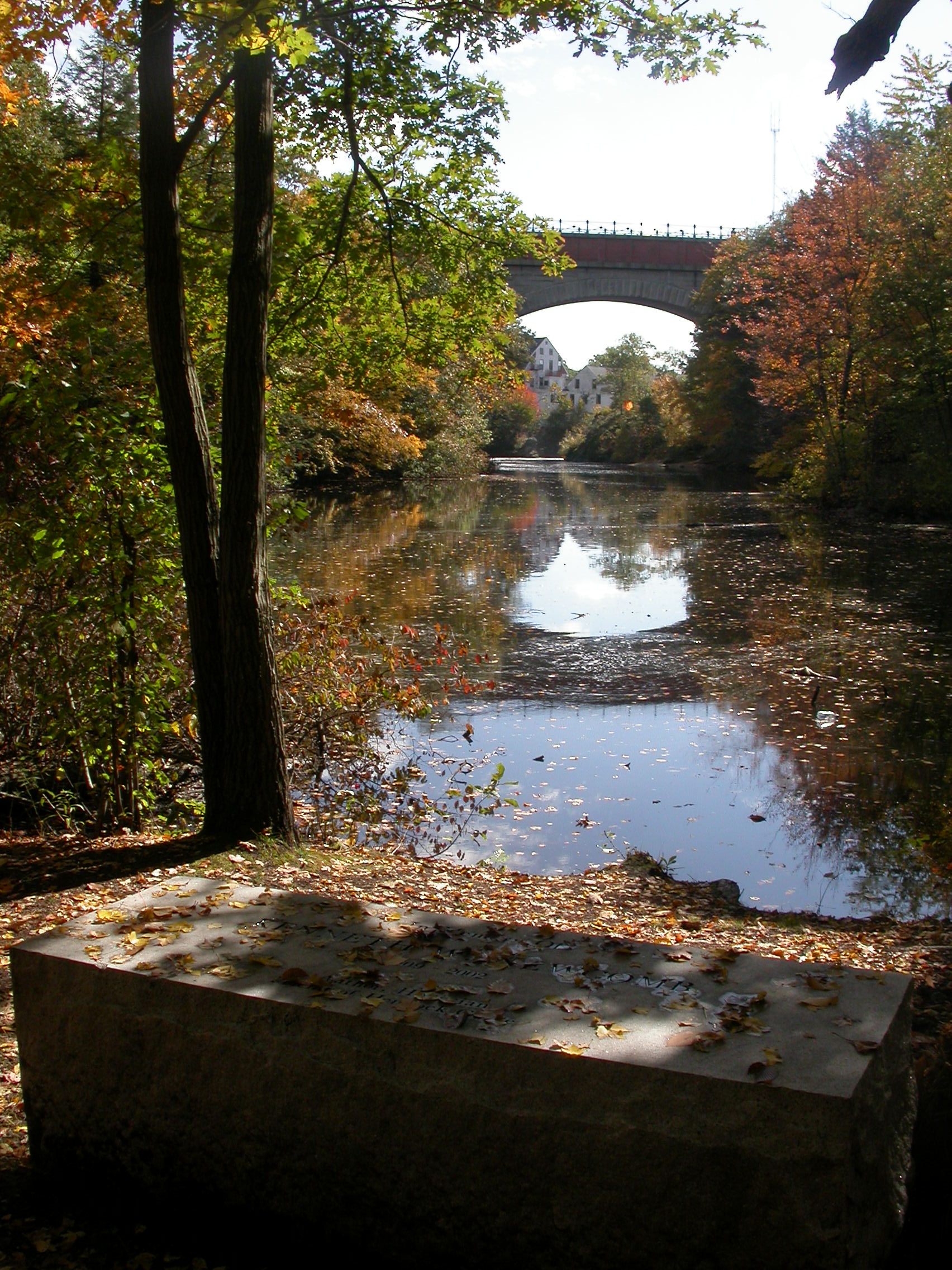
 Echo
Bridge is an imposing structure built in 1876 to carry the conduit of
the Sudbury River Aqueduct over the Charles River. It is 500 ft. in length
and consists of seven arches, five of 37 ft. span and one of 38 ft. The
seventh and largest arch (spanning the river) was the second in size on
this continent at the time of its construction. It is still considered one
of the architectural wonders of the east. The main arch is 130 ft. in
span, the crown is 51 ft. above the river surface, and the top of the
bridge (a walkway) is about 70 ft. above the water. Being only 18 ft. in
width at the crown, it has a very slender and beautiful appearance when
viewed from below. There is a remarkable echo within the arch - the human
voice being rapidly repeated upwards of 15 times, and a pistol shot up to
25 times. The aqueduct is no longer in full use, serving only as a standby
reserve in case of a breakdown in the water supply from the Quabbin
Reservoir. A beautiful example of 19th century engineering skill, it is
listed in the National Register of Historic Places. The Metropolitan
District Commission has jurisdiction over its maintenance, but the
Massachusetts Water Resources Authority owns it.
Echo
Bridge is an imposing structure built in 1876 to carry the conduit of
the Sudbury River Aqueduct over the Charles River. It is 500 ft. in length
and consists of seven arches, five of 37 ft. span and one of 38 ft. The
seventh and largest arch (spanning the river) was the second in size on
this continent at the time of its construction. It is still considered one
of the architectural wonders of the east. The main arch is 130 ft. in
span, the crown is 51 ft. above the river surface, and the top of the
bridge (a walkway) is about 70 ft. above the water. Being only 18 ft. in
width at the crown, it has a very slender and beautiful appearance when
viewed from below. There is a remarkable echo within the arch - the human
voice being rapidly repeated upwards of 15 times, and a pistol shot up to
25 times. The aqueduct is no longer in full use, serving only as a standby
reserve in case of a breakdown in the water supply from the Quabbin
Reservoir. A beautiful example of 19th century engineering skill, it is
listed in the National Register of Historic Places. The Metropolitan
District Commission has jurisdiction over its maintenance, but the
Massachusetts Water Resources Authority owns it.